1. Introduction
As major spatial concentrations of socioeconomic activities, cities are increasingly exposed to compound risks arising from multiple sources of uncertainty
| [1] | Li, C., Zhang, F., Zhu, T., Feng, T., An, P. Evaluation and correlation analysis of land use performance based on entropy-weight TOPSIS method. Transactions of the Chinese Society of Agricultural Engineering. 2013, 29(5), 217-227. (in Chinese). |
| [2] | Shao, Y., Xu, J. Understanding urban resilience: A conceptual analysis based on integrated international literature review. Urban Planning International. 2015, 30(2), 48-54. (in Chinese). |
[1, 2]
. Acute and unexpected disturbances, such as climate change-induced extreme weather events and macroeconomic fluctuations, can propagate through the highly interconnected networks of complex urban systems, potentially triggering cascading failures and posing systemic threats to urban security and long-term sustainable development
. Since the beginning of the 21st century, China’s urbanization has entered a critical phase of transformation. The conventional development model characterized by extensive spatial expansion has gradually shifted toward a more integrated paradigm that places greater emphasis on qualitative improvement, structural optimization, and sustainable development alongside continued urban growth
| [4] | Cai, Z., Liu, Q., Cao, S. Real estate supports rapid development of China's urbanization. Land Use Policy. 2020, 95, 104582.
https://doi.org/10.1016/j.landusepol.2020.104582 |
| [5] | Li, Y., Jia, L., Wu, W., Yan, J., Liu, Y. Urbanization for rural sustainability – Rethinking China's urbanization strategy. Journal of Cleaner Production. 2018, 178, 580-586.
https://doi.org/10.1016/j.jclepro.2017.12.273 |
| [6] | Wei, H., Li, L., Nian, M. China's Urbanization Strategy and Policy During the 14th Five-Year Plan Period. Chinese Journal of Urban and Environmental Studies. 2021, 9(1), 1-33.
https://doi.org/10.1142/S2345748121500020 |
| [7] | Zhang, H., Ma, R., Cui, L., Tian, G., Ma, Z. Exploring the impacts of energy and environmental constraints on China's urbanization process. Computers & Industrial Engineering. 2022, 169, 108170. https://doi.org/10.1016/j.cie.2022.108170 |
[4-7]
. Against this backdrop, integrating resilience-oriented governance into territorial spatial planning and high-quality urban development has become increasingly important for enhancing cities’ capacity to cope with disturbances and advancing the modernization of urban governance
| [5] | Li, Y., Jia, L., Wu, W., Yan, J., Liu, Y. Urbanization for rural sustainability – Rethinking China's urbanization strategy. Journal of Cleaner Production. 2018, 178, 580-586.
https://doi.org/10.1016/j.jclepro.2017.12.273 |
[5]
. Urban resilience, as an emergent property of complex socio-ecological adaptive systems, is shaped not only by the internal characteristics of individual cities but also by interactions and interdependencies among cities, thereby exhibiting pronounced spatial interdependence and potential regional linkages
| [2] | Shao, Y., Xu, J. Understanding urban resilience: A conceptual analysis based on integrated international literature review. Urban Planning International. 2015, 30(2), 48-54. (in Chinese). |
| [8] | Bai, L., Xiu, C., Feng, X., Mei, D., Wei, Y. A comprehensive assessment of urban resilience and its spatial differentiation in China. World Regional Studies. 2019, 28(6), 77-87. (in Chinese). |
[2, 8]
. Accordingly, assessing urban resilience at the urban-agglomeration scale can facilitate the identification of intercity disparities, spatial differentiation, and regional vulnerabilities, while overcoming the limitations of city-specific analyses conducted in isolation. Such an approach can also provide a scientific basis for cross-regional coordination and collaborative resilience governance
| [9] | Xu, J., Shao, Y. Resilient cities: A new shift to urban crisis management. Urban Planning International. 2015, 30(2), 1-3. (in Chinese). |
| [10] | Xu, J., Yang, B., Yuan, C. The impact of supply chain digitalization on urban resilience: Do industrial chain resilience, green total factor productivity and innovation matter? Energy Economics. 2025, 145, 108443.
https://doi.org/10.1016/j.eneco.2025.108443 |
| [11] | Ding, X., Wang, Y., Wang, H., Zhou, Y. Spatiotemporal heterogeneity and synergy driving mechanisms of county ecological resilience in optimized urban agglomerations: integrated geographical detector-Bayesian spatiotemporal model. Scientific Reports. 2026. https://doi.org/10.1038/s41598-026-66902-6 |
[9-11]
. Therefore, a dynamic assessment of urban resilience at the urban-agglomeration scale is essential for understanding the spatiotemporal evolution of urban resilience under an increasingly complex and uncertain risk environment and for informing the development of more sustainable, inclusive, and resilient urban systems
| [3] | Almulhim, A. I. Building Urban Resilience Through Smart City Planning: A Systematic Literature Review. Smart Cities. 2025, 8(1), 22. https://doi.org/10.3390/smartcities8010022 |
| [4] | Cai, Z., Liu, Q., Cao, S. Real estate supports rapid development of China's urbanization. Land Use Policy. 2020, 95, 104582.
https://doi.org/10.1016/j.landusepol.2020.104582 |
| [12] | Zhang, R., Zhou, J., Sun, F., Xu, H., Xing, H. Spatiotemporal Evolution and Driving Factors of Urban Resilience Against Disasters: A Dual Perspective of Urban Systems and Resilience Capacities. Land. 2025, 14(4), 741.
https://doi.org/10.3390/land14040741 |
| [13] | Zhang, T., Sun, Y., Yin, L., Tian, Y., Sun, Y., Zhang, B. Examining heat risk inequality from the perspective of urban resilience. Sustainable Cities and Society. 2025, 131, 106743.
https://doi.org/10.1016/j.scs.2025.106743 |
[3, 4, 12, 13]
.
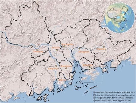
Figure 1. Location of the study area.
The concept of “resilience” originates from the Latin term
resilio, which originally referred to the capacity to rebound or return to a previous state following a disturbance. Holling (1973) introduced the concept into systems ecology, defining resilience as the capacity of an ecosystem to absorb disturbances while maintaining its essential structure and functions without shifting to an alternative regime
. The concept was subsequently extended beyond ecology to a wide range of disciplines, including engineering, economics, and sociology, accompanied by a theoretical evolution from engineering resilience to ecological resilience and, more recently, evolutionary resilience. This conceptual development gradually shifted the emphasis of resilience research from the ability of a system to return to a pre-disturbance equilibrium toward its broader capacity to absorb disturbances, adapt to changing conditions, and undergo transformation when necessary. In the early 21st century, Godschalk (2003) extended the concept of resilience to urban planning, facilitating its application to complex urban systems
. Since then, urban resilience has emerged as a prominent research theme in urban and regional studies, providing an important theoretical framework for understanding how cities respond and adapt to increasingly complex and uncertain disturbances. However, the multidimensional and dynamic nature of urban resilience also highlights the need for assessment frameworks that can capture differences across cities and changes over time.
Alongside the conceptual development of urban resilience, increasing attention has been devoted to the construction of multidimensional and context-specific assessment frameworks. For example, Sharifi et al. (2016) examined urban energy systems and proposed a set of principles and quantitative criteria for assessing energy resilience
| [16] | Sharifi, A., Yamagata, Y. Principles and criteria for assessing urban energy resilience: A literature review. Renewable and Sustainable Energy Reviews. 2016, 60, 1654-1677.
https://doi.org/10.1016/j.rser.2016.03.028 |
[16]
. Their framework incorporated multiple stages of resilience, including preparedness, absorption, recovery, and long-term adaptation, thereby providing a systematic basis for evaluating the capacity of urban energy systems to respond and adapt to persistent stresses such as climate change. In China, urban resilience research has developed in close association with the country’s distinctive urbanization trajectory and spatial governance framework. In particular, the development of urban agglomerations and metropolitan areas has become an important spatial strategy for promoting coordinated and differentiated development among cities and towns of different sizes. Against this institutional and spatial backdrop, Chinese scholars have increasingly emphasized the development and application of quantitative approaches to urban resilience assessment, with research gradually evolving from single-dimensional measurement toward multidimensional and comprehensive evaluation frameworks
| [8] | Bai, L., Xiu, C., Feng, X., Mei, D., Wei, Y. A comprehensive assessment of urban resilience and its spatial differentiation in China. World Regional Studies. 2019, 28(6), 77-87. (in Chinese). |
| [17] | Fang, C., Zhang, G., Xue, D. High-quality development of urban agglomerations in China and construction of science and technology collaborative innovation community. Acta Geographica Sinica. 2021, 76(12), 2898-2908. (in Chinese). |
[8, 17]
From a multidimensional perspective, Zhu and Sun (2020), for instance, conducted a comparative assessment of urban resilience across the Beijing–Tianjin–Hebei, Yangtze River Delta, and Pearl River Delta urban agglomerations
| [18] | Zhu, J., Sun, H. Research on spatial-temporal evolution and influencing factors of urban resilience of China's three metropolitan agglomerations. Soft Science. 2020, 34(2), 72-79. (in Chinese). |
[18]
. By integrating the entropy-weighting method with exploratory spatial data analysis, they characterized the spatiotemporal differentiation and spatial heterogeneity of urban resilience and further employed spatial panel econometric models to examine the heterogeneous effects of key socioeconomic and institutional determinants, including fiscal regulation and market vitality. Nevertheless, existing studies have differed considerably in their selection of resilience dimensions, indicators, and analytical scales, and the dynamic evolution of multidimensional resilience within individual urban agglomerations requires further investigation.
Urban agglomerations have become key hubs for national and regional development, concentrating socioeconomic activities, development capacity, and regional competitiveness
| [1] | Li, C., Zhang, F., Zhu, T., Feng, T., An, P. Evaluation and correlation analysis of land use performance based on entropy-weight TOPSIS method. Transactions of the Chinese Society of Agricultural Engineering. 2013, 29(5), 217-227. (in Chinese). |
| [18] | Zhu, J., Sun, H. Research on spatial-temporal evolution and influencing factors of urban resilience of China's three metropolitan agglomerations. Soft Science. 2020, 34(2), 72-79. (in Chinese). |
[1, 18]
. Among them, the PRDUA is one of China’s most economically dynamic and highly urbanized regions (
Figure 1). Comprising nine prefecture-level cities, including Guangzhou and Shenzhen, the Pearl River Delta Urban Agglomeration (PRDUA) serves as a major engine of national economic growth while also representing a complex urban region exposed to interacting natural hazards, ecological pressures, and socioeconomic risks. These characteristics make the PRDUA a valuable empirical setting for examining the evolution of urban resilience and its spatial differentiation among cities. Despite its strategic significance, research on urban resilience in the PRDUA remains relatively fragmented compared with that on other major urban agglomerations, such as the Yangtze River Delta. Existing studies have largely focused on individual cities or specific dimensions of resilience, whereas systematic assessments that capture the multidimensional and dynamic characteristics of resilience across the PRDUA as a whole remain limited. In particular, insufficient attention has been paid to how multidimensional urban resilience has evolved across cities in the PRDUA in recent years. To address these gaps, this study develops a comprehensive urban resilience evaluation framework encompassing four dimensions—social, economic, ecological, and infrastructure resilience—and applies it to nine cities in the PRDUA using data from 2016, 2018, 2020, 2022, and 2023. An entropy-weighted TOPSIS model is employed to quantify urban resilience and systematically examine its temporal evolution and spatial differentiation. By revealing the spatiotemporal dynamics and intercity disparities of urban resilience within the PRDUA, this study contributes to the existing literature by providing an updated multidimensional assessment at the urban-agglomeration scale and offers empirical evidence to support differentiated resilience enhancement and regional governance.
3. Methods
3.1. Construction of the Evaluation Indicator System
Drawing on the national standard Guide for Safety Resilient City Evaluation (GB/T 40947–2021), the evaluation frameworks proposed by Zhu and Sun (2020) and Lowe et al. (2024), and the socioeconomic and environmental characteristics of the PRDUA
| [18] | Zhu, J., Sun, H. Research on spatial-temporal evolution and influencing factors of urban resilience of China's three metropolitan agglomerations. Soft Science. 2020, 34(2), 72-79. (in Chinese). |
| [23] | Lowe, M., Bell, S., Briggs, J., McMillan, E., Morley, M., Grenfell, M., Sweeting, D., Whitten, A., Jordan, N. A research-based, practice-relevant urban resilience framework for local government. Local Environment. 2024, 29(7), 886-901.
https://doi.org/10.1080/13549839.2024.2318571 |
[18, 23]
, this study develops a comprehensive urban resilience evaluation framework consisting of 21 indicators across four dimensions: social, economic, ecological, and infrastructure resilience (
Table 1).
3.2. Urban Resilience Evaluation Model
3.2.1. Determination of Indicator Weights Using the Entropy-Weighting Method
Entropy was originally introduced as a fundamental concept in thermodynamics. In 1948, C. E. Shannon extended the concept to information theory and proposed information entropy as a measure of uncertainty in a system
. The entropy-weighting method is an objective weighting approach based on information entropy
| [25] | Du, T., Xie, X., Liang, H., Huang, A., Han, Q. County economy comprehensive evaluation and spatial analysis in Chongqing City based on entropy weight-TOPSIS and GIS. Economic Geography. 2014, 34(6), 40-47. (in Chinese). |
| [26] | Miao, C., Na, M., Chen, H., Ding, M. Urban resilience evaluation based on entropy-TOPSIS model: a case study of county-level cities in Ningxia, Northwest China. International Journal of Environmental Science and Technology. 2025, 22(6), 4187-4202. https://doi.org/10.1007/s13762-024-05880-6 |
[25, 26]
. It determines the importance of individual indicators according to the degree of dispersion in the observed data, thereby reducing the influence of subjective judgment on weight assignment. It has consequently become a widely used method for determining indicator weights in multi-attribute decision analysis
| [25] | Du, T., Xie, X., Liang, H., Huang, A., Han, Q. County economy comprehensive evaluation and spatial analysis in Chongqing City based on entropy weight-TOPSIS and GIS. Economic Geography. 2014, 34(6), 40-47. (in Chinese). |
[25]
. The basic principle is that a larger entropy value indicates a more uniform distribution of an indicator across the evaluated objects and, consequently, a weaker capacity to discriminate among them. Such an indicator is therefore assigned a smaller weight. The calculation procedure is as follows.
Table 1. Urban resilience evaluation indicator system.
Dimension | Indicator | Indicator meaning |
Social resilience | Permanent resident population (10,000 persons) | Urban population size |
Proportion of urban population in the permanent resident population (%) | Level of urbanization |
Population density (persons/km²) | Urban population density |
Number of schools | Level of urban education provision |
Proportion of basic medical insurance participants in the permanent resident population (%) | Social security capacity |
Economic resilience | Proportion of science and technology expenditure in general public budget expenditure (%) | Urban investment in scientific and technological innovation |
GDP per capita (CNY) | Level of urban economic development |
General public budget revenue per capita (CNY) | Municipal fiscal capacity |
Per capita disposable income of urban residents (CNY) | Residents' disposable income and consumption capacity |
Total fixed-asset investment (CNY 10,000) | Urban development potential |
Ecological resilience | Green coverage rate of built-up areas (%) | Level of urban ecological greening |
Sewage treatment rate (%) | Urban wastewater treatment capacity |
Proportion of days meeting ambient air-quality standards (%) | Urban air quality |
Harmless treatment rate of municipal solid waste (%) | Municipal solid-waste treatment capacity |
Comprehensive utilization rate of general industrial solid waste (%) | Urban resource-recycling capacity |
Infrastructure resilience | Hospital beds per 10,000 residents | Urban healthcare service capacity |
Number of medical and health institutions per km² | Spatial availability of healthcare resources |
Health professionals per 10,000 residents | Professional healthcare service capacity |
Gas penetration rate (%) | Gas supply capacity |
Urban road area per capita (m²) | Urban road infrastructure capacity |
Water resources per unit area (m³/m²) | Urban water-resource availability |
1) Construction of the multi-indicator evaluation matrix.
A judgment matrix is constructed for a evaluation objects and b evaluation indicators.
2) Data preprocessing.
Because the indicators differ in direction, units, and orders of magnitude, the min-max normalization method is used to standardize the original dataset. Indicators are divided into positive and negative indicators. A positive indicator contributes more strongly to urban resilience as its value increases, and is normalized as follows:
(2)
A negative indicator has a weaker positive effect on urban resilience as its value increases, and is normalized as follows:
(3)
where Xij represents the original value of indicator j for city i; MaxXj is the maximum value of indicator j; MinXj is the minimum value of indicator j; and yij denotes the standardized value of indicator j for city i.
According to the indicator system adopted in this study, population density is the only negative indicator, while all remaining indicators are treated as positive indicators. After normalization, all indicator values fall within the interval [0, 1]. To avoid zero values in subsequent calculations, 0.01 is added to all standardized values.
3) Calculation of information entropy ej and entropy weight Wj.
Based on the standardized data, the proportion of the evaluation value of city i under indicator j is first calculated as follows:
The information entropy ej of indicator j is then calculated as follows:
The information utility value gj is calculated as follows:
A larger information utility value indicates that the corresponding indicator makes a greater contribution to the comprehensive evaluation. The final entropy weight Wj is subsequently calculated, where 0 ≤ Wj ≤ 1.
3.2.2. Calculation of Urban Resilience Using the TOPSIS Model
TOPSIS (Technique for Order Preference by Similarity to an Ideal Solution) is a multi-criteria ranking method based on the distance between each evaluated object and an ideal solution
| [25] | Du, T., Xie, X., Liang, H., Huang, A., Han, Q. County economy comprehensive evaluation and spatial analysis in Chongqing City based on entropy weight-TOPSIS and GIS. Economic Geography. 2014, 34(6), 40-47. (in Chinese). |
| [26] | Miao, C., Na, M., Chen, H., Ding, M. Urban resilience evaluation based on entropy-TOPSIS model: a case study of county-level cities in Ningxia, Northwest China. International Journal of Environmental Science and Technology. 2025, 22(6), 4187-4202. https://doi.org/10.1007/s13762-024-05880-6 |
[25, 26]
. Based on a normalized decision matrix, the method identifies the positive and negative ideal solutions and calculates the geometric distance of each evaluated object from these two reference points. The relative closeness of each object to the positive ideal solution is then used to assess its comparative performance
| [1] | Li, C., Zhang, F., Zhu, T., Feng, T., An, P. Evaluation and correlation analysis of land use performance based on entropy-weight TOPSIS method. Transactions of the Chinese Society of Agricultural Engineering. 2013, 29(5), 217-227. (in Chinese). |
| [25] | Du, T., Xie, X., Liang, H., Huang, A., Han, Q. County economy comprehensive evaluation and spatial analysis in Chongqing City based on entropy weight-TOPSIS and GIS. Economic Geography. 2014, 34(6), 40-47. (in Chinese). |
[1, 25]
. The procedure is as follows.
Construction of the entropy-weighted TOPSIS model.
The indicator weights derived from the entropy-weighting method are applied to the standardized data to obtain a weighted normalized matrix, thereby reducing the influence of subjective weighting:
Determination of the positive ideal solution and negative ideal solution .
(9)
(10)
where Z1j denotes the value of indicator j for the first evaluation object;
denotes the positive ideal solution for indicator j; and denotes the negative ideal solution for indicator j.
Calculation of Euclidean distances from the positive and negative ideal solutions.
(11)
(12)
where denotes the distance between evaluation object i and the positive ideal solution; anddenotes the distance between evaluation object i and the negative ideal solution.
Calculation of the relative closeness coefficient Ci.
A larger Ci indicates a higher level of urban resilience, whereas a smaller value indicates a lower level of resilience.
Table 2. Urban resilience indices of cities in the PRDUA.
City | 2016 | 2018 | 2020 | 2022 | 2023 |
Guangzhou | 0.577 | 0.580 | 0.612 | 0.601 | 0.603 |
Foshan | 0.384 | 0.401 | 0.418 | 0.415 | 0.406 |
Shenzhen | 0.646 | 0.651 | 0.662 | 0.667 | 0.687 |
Zhaoqing | 0.247 | 0.287 | 0.303 | 0.294 | 0.303 |
Dongguan | 0.364 | 0.369 | 0.366 | 0.354 | 0.375 |
Huizhou | 0.343 | 0.323 | 0.330 | 0.338 | 0.314 |
Zhuhai | 0.462 | 0.480 | 0.481 | 0.471 | 0.471 |
Zhongshan | 0.289 | 0.294 | 0.317 | 0.302 | 0.307 |
Jiangmen | 0.258 | 0.290 | 0.315 | 0.302 | 0.304 |
3.3. Results
3.3.1. Comprehensive Urban Resilience Across Cities in the Pearl River Delta
The assessment results indicate that urban resilience across the Pearl River Delta Urban Agglomeration generally increased between 2016 and 2023, although the trajectories varied considerably among cities (
Table 2). Shenzhen was the only city to maintain continuous and relatively stable growth throughout the study period, whereas the other cities exhibited varying degrees of stage-specific fluctuation. Overall, urban resilience in the PRDUA exhibited a stage-dependent trajectory characterized by an initial increase, subsequent stabilization, and localized fluctuations (
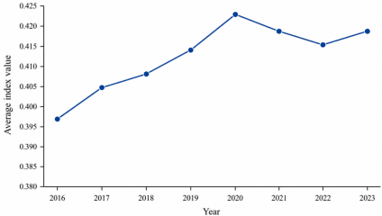
Figure 2). From 2016 to 2020, the average resilience index increased steadily from 0.3967 to 0.4227, corresponding to an average annual increase of approximately 1.6%. The period from 2016 to 2018 represented a relatively rapid growth stage, while the growth rate slowed between 2018 and 2020 but remained positive. The regional average reached a period-specific peak of 0.4227 in 2020. After 2020, overall resilience entered a period of high-level adjustment and fluctuation. The regional mean decreased slightly from 0.4227 in 2020 to 0.4160 in 2022, representing a decline of approximately 1.6% from the peak. Between 2022 and 2023, the resilience level stabilized and recovered, with the regional average increasing to 0.4189.
Figure 2. Changes in the average urban resilience index of the PRDUA.
3.3.2. Spatiotemporal Evolution of Urban Resilience
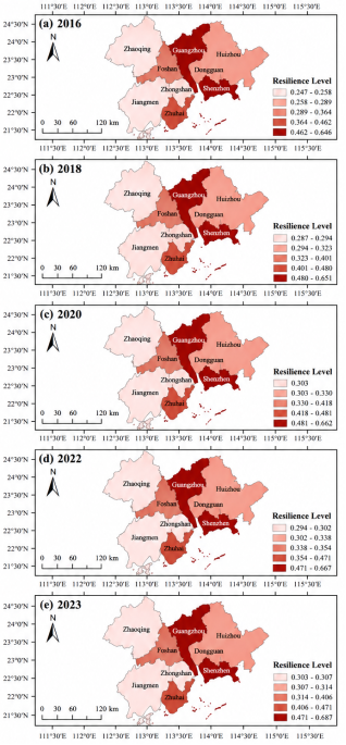
The spatial distribution of resilience in the Pearl River Delta Urban Agglomeration exhibited a pronounced core-periphery pattern, while individual cities also differed considerably in their resilience trajectories and stability (
Figure 3). Overall, cities in the central part of the region showed substantially higher resilience than those on the eastern and western peripheries. Huizhou in the eastern part of the region exhibited slightly higher resilience than Zhaoqing in the north and Jiangmen in the west. Among the central cities, Shenzhen, Guangzhou, and Zhuhai consistently maintained relatively high resilience levels and remained among the regional leaders throughout the study period. The adjacent cities of Foshan and Dongguan also exhibited higher resilience than most peripheral cities. Shenzhen and Guangzhou, as the principal regional cores, maintained and further consolidated their resilience advantages, strengthening their leading roles within the urban agglomeration. In contrast, peripheral cities such as Zhaoqing and Jiangmen exhibited greater fluctuations and larger variations in resilience. Intermediate cities such as Foshan and Dongguan displayed differentiated trajectories, reflecting their distinct development pathways.
4. Discussion
4.1. Urban Resilience and Its Spatiotemporal Evolution in the PRDUA
Enhancing urban resilience has become an important strategic objective in China's new-type urbanization process and represents a key pathway toward sustainable urban development. Against the combined background of the implementation of the 14th Five-Year Plan and the carbon-peaking and carbon-neutrality goals, cities face increasing challenges associated with climate change and the accumulation of systemic vulnerabilities
| [27] | Wang, S., Cui, Z., Lin, J., Xie, J., Su, K. The coupling relationship between urbanization and ecological resilience in the Pearl River Delta. Journal of Geographical Sciences. 2022, 32(1), 44-64. https://doi.org/10.1007/s11442-022-1935-3 |
| [28] | Xu, X., Wang, M., Wang, M., Yang, Y., Wang, Y. The Coupling Coordination Degree of Economic, Social and Ecological Resilience of Urban Agglomerations in China. International Journal of Environmental Research and Public Health. 2023, 20(1), 413. https://doi.org/10.3390/ijerph20010413 |
[27, 28]
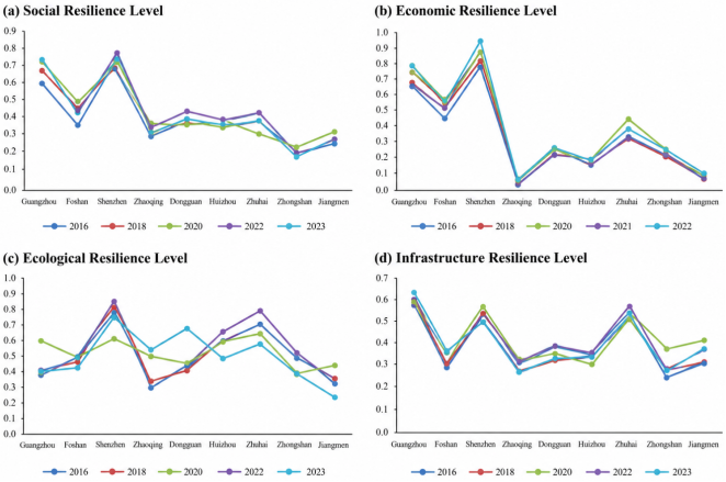
. Integrating resilience principles into spatial planning, industrial transformation, and urban governance is therefore of growing strategic importance. This study evaluates the resilience of cities in the Pearl River Delta Urban Agglomeration from four dimensions: social, economic, ecological, and infrastructure resilience (
Figure 4).
The rapid increase in overall urban resilience between 2016 and 2020 coincided with rapid economic development and the implementation of initiatives such as sponge-city construction, comprehensive remediation of black and odorous water bodies, and improvements in the equal provision of public services. These developments contributed to the strengthening of multiple components of urban resilience. These developments may have been associated with improvements in multiple dimensions of urban resilience. The decline in the resilience index between 2020 and 2022 reflects the systemic effects of sudden public-health shocks, including disruptions to the movement of production factors, imbalances between the supply of and demand for social services, and weaknesses in emergency management. Subsequently, improvements in dual-purpose emergency facilities, flexible employment policies, and digital governance systems contributed to the recovery of regional resilience. Cross-city emergency coordination under regional development strategies and broader implementation of ecological compensation mechanisms also supported this recovery. By 2022-2023, the contributions of social and ecological resilience had recovered to 47.3% and 31.6%, respectively, while the overall regional resilience index increased to 0.4189. This pattern indicates a transition from rapid resilience improvement toward a relatively stable stage in which further gains may increasingly depend on addressing remaining weaknesses and improving coordination across resilience dimensions. These results suggest that the Pearl River Delta Urban Agglomeration has moved beyond a stage dominated by rapid incremental resilience construction and has entered a relatively high-level phase characterized by optimization of existing assets and coordinated efforts to address remaining weaknesses. Further improvements in regional resilience are therefore unlikely to depend solely on rapid progress within individual subsystems. Instead, they will increasingly require stronger cross-city flows of resources and greater coordination among social, economic, ecological, and infrastructure subsystems.
Figure 3. Spatial distribution of urban resilience levels in the PRDUA.
As a mature urban agglomeration with an urbanization rate exceeding 85%, the Pearl River Delta has largely moved beyond the stage of large-scale infrastructure expansion aimed at addressing basic deficiencies and has entered a phase of stock optimization at a relatively high level of development. Previous studies have often treated the Pearl River Delta as a subsample in comparative analyses of China's major urban agglomerations, leading primarily to broad conclusions that its overall resilience is relatively high. For example, Zhu and Sun (2020) reported that the average annual growth rate of resilience in the Pearl River Delta was approximately 1.6%, lower than the 2.3% reported for the Beijing-Tianjin-Hebei Urban Agglomeration during 2006-2020 but slightly higher than the 1.4% reported for the Yangtze River Delta over the corresponding period
| [18] | Zhu, J., Sun, H. Research on spatial-temporal evolution and influencing factors of urban resilience of China's three metropolitan agglomerations. Soft Science. 2020, 34(2), 72-79. (in Chinese). |
[18]
. Such differences may reflect the different stages of urbanization reached by the three urban agglomerations. In comparison, the present study provides a more recent assessment of the PRDUA and further reveals its resilience dynamics across social, economic, ecological, and infrastructure dimensions. This study further shows that the shock occurring around 2020 exerted a short-term downward effect on regional resilience, whereas social and ecological resilience subsequently played important roles in supporting recovery. This finding is also broadly consistent with the cost-capacity-efficiency framework proposed by Peng et al. (2021)
| [29] | Peng, C., Lin, Y., Wu, Y., Peng, Z. Urban resilience evaluation of the Yangtze River Economic Belt based on “cost-capacity-efficiency”. Resources and Environment in the Yangtze Basin. 2021, 30(8), 1795-1808. (in Chinese). |
[29]
. For peripheral cities such as Zhaoqing and Huizhou, constraints on further resilience improvement appear to be shifting away from cost-side deficiencies such as insufficient infrastructure investment toward capacity-side constraints, including relatively weak industrial structures and lagging public-service provision. Accordingly, future policies for coordinated resilience enhancement should gradually shift from uniform infrastructure-oriented interventions toward differentiated strategies tailored to cities at different levels of resilience
| [30] | Zhou, C., Wang, Y., Xu, Q., Li, S. The new process of urbanization in the Pearl River Delta. Geographical Research. 2019, 38(1), 45-63. (in Chinese). |
[30]
. High-resilience cities such as Shenzhen and Guangzhou could further strengthen regional cooperation and resource sharing, while cross-city collaborative networks could be improved to support resilience enhancement across the PRDUA.
4.2. Temporal Evolution and Multidimensional Heterogeneity of Urban Resilience
Urban resilience in the Pearl River Delta Urban Agglomeration exhibits substantial spatial differentiation, characterized by a clear core-periphery pattern, with relatively high-resilience core cities and lower-resilience peripheral cities. Guangzhou and Shenzhen form a high-resilience core with relatively strong performance in economic and infrastructure resilience. Secondary cities such as Foshan and Dongguan exhibit more complex resilience trajectories across different dimensions. Peripheral cities such as Zhaoqing and Jiangmen have remained at relatively low resilience levels and show relatively weak performance in several resilience dimensions. These spatial differences may be associated with variations in economic development, ecological conditions, infrastructure, and social capacity across cities. The regional resilience index in 2023 was approximately 5.6% higher than that in 2016, indicating that resilience enhancement did not follow a simple linear trajectory during the study period, but rather showed fluctuations across different dimensions and cities. Between 2016 and 2023, substantial differences were observed among cities in their resilience trajectories. In terms of social resilience, Shenzhen and Guangzhou consistently maintained leading positions, whereas Foshan and Dongguan exhibited an initial increase followed by a decline. Regarding economic resilience, Shenzhen and Guangzhou retained clear advantages, while Zhaoqing and Jiangmen remained at relatively low levels. Economic resilience was generally stable across most cities, with comparatively larger changes observed in Shenzhen and Zhuhai. For ecological resilience, Shenzhen and Zhuhai generally performed strongly, although substantial fluctuations were observed among cities, and Jiangmen and Foshan showed considerable potential for further improvement. With respect to infrastructure resilience, Guangzhou, Zhuhai, and Shenzhen remained at relatively high levels, Foshan exhibited a fluctuating upward trajectory, and Jiangmen showed a downward trend.
Figure 4. Spatial Distribution of Urban Resilience across Different Dimensions.
Multidimensional heterogeneity was also evident at the city level. Shenzhen experienced continued resilience enhancement accompanied by relatively strong performance in technological innovation and urban governance. Guangzhou remained a regional core city, although intensive urban development was accompanied by ecological resilience below the regional average during parts of the study period. In Zhuhai, social and economic resilience remained relatively weaker than its ecological and infrastructure resilience, suggesting potential constraints related to social and economic resilience. Among cities with intermediate resilience levels, Foshan showed relatively weaker ecological resilience, which may be associated with its industrial structure, while Dongguan's economic resilience showed limited improvement, potentially reflecting its exposure to fluctuations associated with an export-oriented economy. Zhongshan continues to face challenges related to infrastructure development and ecological restoration. Among peripheral cities, Huizhou has shown initial progress in industrial transformation but remains relatively vulnerable to external shocks showed some improvement but remained at a relatively low overall resilience level, while Zhaoqing and Jiangmen remained at relatively low levels of economic resilience, because of limited endogenous growth momentum and relatively rigid industrial structures potentially reflecting constraints associated with endogenous growth capacity and industrial structure. Comparative research on China's three major urban agglomerations indicates that their overall resilience has generally increased since 2000, with the Yangtze River Delta maintaining a relatively high level and the Pearl River Delta experiencing faster growth than the Beijing-Tianjin-Hebei region after 2015
| [18] | Zhu, J., Sun, H. Research on spatial-temporal evolution and influencing factors of urban resilience of China's three metropolitan agglomerations. Soft Science. 2020, 34(2), 72-79. (in Chinese). |
[18]
. In terms of internal structure, the Pearl River Delta has been characterized by a pyramid-shaped resilience distribution, with substantial internal disparities and a relatively large number of low-resilience cities
| [18] | Zhu, J., Sun, H. Research on spatial-temporal evolution and influencing factors of urban resilience of China's three metropolitan agglomerations. Soft Science. 2020, 34(2), 72-79. (in Chinese). |
[18]
. The spatial differentiation identified in this study is broadly consistent with these previous findings, while providing updated evidence on the multidimensional resilience trajectories of individual cities within the PRDUA. Future resilience policies should therefore strengthen regional coordination and resource sharing, while adopting differentiated strategies to address the specific weaknesses of cities at different resilience levels.


 Share This Article
 Twitter
 Linked In
 Facebook

 Copy
 Download